Distance: 17 km
walk
Duration: 3h
Difficulty : Difficult
Elevation: 311 D +
PUISSEGUIN
PUISSEGUIN
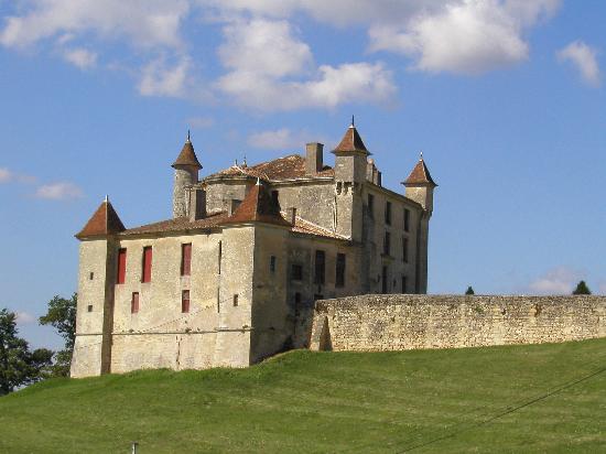
Discover Puisseguin during this fifteen-kilometre medieval walk. This village occupied a strategic location during the 100 Years War. Not far from the town, the hamlet of Monbadon is also a major heritage site with its Romanesque church and feudal castle.
Your itinerary
1
Step 1
From the church square, take the direction of rue du Mayne on the right (towards “la société des eaux”). At the end of the road, continue to the left. At the first intersection, continue straight ahead then continue in this direction until the crossing of the D130 road.
2
Step 2
At the “Stop”, turn left, then turn into the first street on the right. Continue straight until the entrance of a hamlet. Turn right then continue downhill to the crossroads. Turn right and continue on the left side on the main path (Lieu-dit Baisse).
3
Step 3
Turn right into the path between the two water points on your left. Take the path on the left.
4
Step 4
Turn right then go straight on rue de Guillotin. At the intersection, turn left then immediately right. Continue straight until you reach the D17. Turn right then walk along the departmental road. (If you want to end the hike here, you can continue straight back to the starting point). Take the path on the left before the town hall, just after Ch. Beauséjour (right side). Continue straight until Ch. Bel-Air.
5
Step 5
Continue on the right and stay on this paved road until the next crossing, at the end of rue du Barrail. At the end of the path, turn left. At the intersection, keep left and continue to the next intersection.
6
Step 6
Turn right. Walk along the departmental road then take the next left turn. Continue on this path until the end of the path (yellow and green markers). Take the street on the left (3rd beacon) and continue on this path which passes between the vines to the end of the plot.
7
Step 7
Turn left and continue straight to reach a dirt road. When the path veers to the left, leave it and turn right to walk between the rows of vines. Continue straight ahead then join the road. Cross it and continue straight until the next crossing (follow “medieval circuit”).
8
Step 8
Turn right and walk to the entrance of Ch. de Roques. Turn left then continue straight. The path veers to the right and leads you to a pond.
9
Step 9
At the pond, turn right and continue straight until you reach a paved road (green markers). Turn right then take the next road on the left (beacon). Then take the next path on your right, then at the end turn left.
10
Step 10
Stay on this path, which becomes a dirt road, until you can no longer continue straight because of the trees in front of you. Turn right, then right again to go along the trees and finally turn left. You reach a paved road. Take it to the next path going to the left.
11
Step 11
Take this path and continue straight until the end. Continue to the left and continue to the next crossing (pass in front of Ch. des Faures). At the end of the path, continue to the right. This path called "de Faure Monbadon" will take you to the departmental road D21. Observe from this point dominating the valley and the Ch. de Monbadon.
12
Step 12
At the crossroads with the departmental road, turn right in the direction of “Monbadon, commune of Puisseguin”. Take the 1st street on the right towards “Eglise romane de Monbadon". Pass in front of the church and its cemetery then continue straight. Then take the path on the left which crosses the grove and joins the D21. Turn left. Leave it take the first path on the right.At the end, continue left and stay on this road to join the D123-E7 (sign "Stop" + Ch. le Bernat on your left).
13
Step 13
At the departmental road, turn left to reach the center of Puisseguin, your starting point.