THE VERDON ON SEA
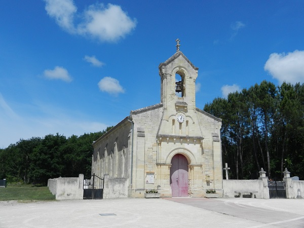
The Hôpital variant, a historic section of the Soulac route similar to the route taken by the pilgrims of yesteryear in the Nord Médoc. Nearly 1000 years ago, pilgrims from northern Europe disembarked by the thousands at Soulac-sur-Mer to begin their journey to Compostela, Rome or Jerusalem. After their devotions at Sainte-Véronique, they went to the Hospital de la Grayanès where the Hospitallers of Saint-Jean-de-Jérusalem had founded an important commandery (the 4th of the Order in France).
The chapel of Saint-Jean-Baptiste de L'Hôpital is the last witness to this.
The chapel of Saint-Jean-Baptiste de L'Hôpital is the last witness to this.
Your itinerary
1
From the Pointe de Grave to the Maison de Grave
Leaving the landing stage, the arrows “Chemins de Compostelle - Voie de Soulac – European Cultural Route” on the sidewalk opposite take you along various restaurants then turn right towards the station of the small tourist train Pointe de Grave-Soulac (PGVS). If you do not go through the Pointe triangle, we recommend that you take the Allée du Sémaphore towards the American memorial and turn left to reach the start of the Vélodyssée! Cross the railway line and continue 200m to the Vélodyssée which runs along under the cover of a beautiful deciduous forest, the PGVS route (operates in July-August). You won't leave it until Soulac to go as short as possible!
2
From the house of Grave to Arros
At the edge of the path, the Maison de Grave, a group of buildings built around 1850. On the right when leaving the cottage, a jacquaire marking in the footsteps of the GR8 offers a bucolic route and fabulous panoramas but it is steeper (with stairs ). The marked path again crosses the track of the GR8. It allows you to cross the dune of Arros, preserved from marine erosion thanks to the defense works implemented in the 1930s, which give this site of the Atlantic wall an exceptional character. The path joins the terminus of the little train to the south. Shaded picnic area.
3
From Arros to the Basilica of Notre-Dame-de-la-fin-des-Terres
At the first houses in Soulac, go straight on rue Le Carvennec as far as the 1st street on the right, at the seafront and the memorial of the battle for the liberation of April 1945. On the avenue de la brigade Carnot, a replica of the famous Statue of Liberty faces the ocean Continue on the seafront and turn left into rue Jeanne d'Arc, then right for a few meters, and immediately left into rue du Maréchal d'Ornano, with in focus, the Basilica of Our Lady of the End of the Lands.
4
From the basilica to Grayan
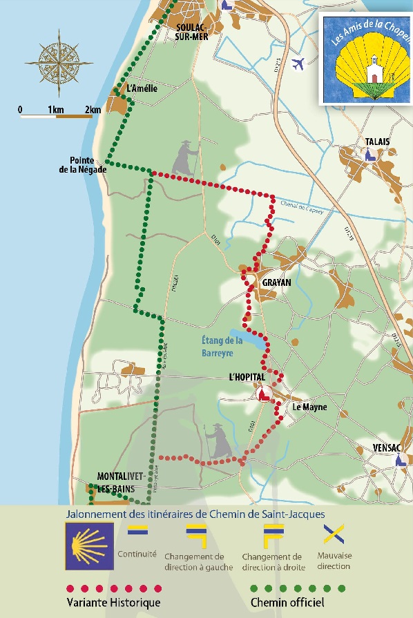
From the Notre-Dame de la Fin des Terres basilica, reach the seafront then turn left, follow the Vélodyssée towards the south. It runs along the boulevard de l'Amélie. After 350 m, a quieter route taking the boulevard Marsan de Montbrun on the left for about sixty meters then on the right, the peaceful municipal road of Tottoral which becomes the Négade pass at km 4,9. Amelie. Continue left on Boulevard Guy Albospeyre for 500m. Turn right into the “passe de la Négade” and continue straight to the end of this road. Pointe de la Négade. On the right, a splendid view of the ocean and GURP cove. Take the Vélodyssée as far as the bend to the right. At the sign "Chemin historique de l'Hôpital", leave the Vélodyssée, continue straight on the cycle path (greenway l'Amélie-Talais) following the signs for Saint Jacques towards the village of Grayan then that of the Hospital. The shorter but very monotonous dune path along the Vélodyssée goes to the right, runs along EURONAT and joins the marked path coming from the Hospital at Km 24,7.
5
From Grayan to the Etangs de la Barreyre
The track crosses the D101 (route des Lacs) and runs along the Capsey channel for 2,1 km to a footbridge. Cross the channel on this footbridge. The path joins a paved road to follow until a Y. On both sides, it is the "path of Placettes". Turn right for 100 m. On the left, direction Camping “les Franquettes” and its pedestrian access at 600 m. Turn right on the "Chemin des Eyres" along the first houses of Grayan-et-l'Hôpital. End of the "chemin des Eyres", at the stop sign turn left, continue for 700 m to another stop. Turn right, follow the road to Soulac for 80 m to take a grassy path on the left which ends alongside a golf course on the right, by a cycle track and the road of the Ocean. Crossroads (locality Videau) with the road of the Ocean. To get supplies, turn left towards the D101: left again towards the Grayan supermarket, or right, to go to the camping des Familles 1km away. Cross the ocean road to follow the sports complex on the “Chemin de Piqueau”. , the forest path in the direction of the pond of Barreyre. At the next crossing in the forest, bear right. It is possible to circumvent the pond by the path on the right out of hunting season. There is a gravelled path which is the access to the Barreyre pond by vehicles, to follow straight on for 130 m until the junction with the D101. Turn right (! Very busy road to be followed with caution for 380m). Turn right on the "Chemin de la Bérarde". At the T with a paved road, turn left for 70 m to the stop sign with the D101, cross to take the "Chemin du Touquet" opposite.
6
Ponds at the Chapel
At the T turn right for 50 m and at the Y take the “rue de l'Eglise” on the right Grayan and the Hospital: Roundabout of the pilgrims of the Hospital, continue opposite; 140 m on the D101 "l'église de l'Hôpital" Turn left "rue de Compostelle". This street leads to the heart of the village of the Hospital in the “Le Pèlerin” district. Leave rue des Hospitaliers on the right, further left, rue des Templiers. Turn right onto chemin de la Tiouleyre. At Y follow left. At the T «route des Grigots» turn right. Passage in front of the “Camping de Tastesoule”.
7
From the Chapel to Montalivet
At the T with the D101, turn left, follow the road for 380 m and cross to take a sandy path in the forest, to follow straight west. Connection with the Vélodyssée, turn left and follow to the paved road "Route de l'Océan" which leads to Vensac-Océan at the same place as the cycle path. At the entrance to Montalivet, turn left onto avenue de Joinville-le-Pont as far as avenue de l'Océan (main artery). On the seafront, stele in memory of the heroic operation FRANKTON. Join the Vélodyssée south of Montalivet via avenue Marcel Martin. Take the side of this track for 6,7 km until it turns left at a right angle. Continue straight on the ONF road announced by a white gate. After the 2nd white portico, the forest road becomes a sandy track.
8
From Montalivet to Pin Sec
Continue on the sandy path marked with a beacon located after a crossing of tracks (= do not turn). At the next marked crossroads, turn right and 100 m further on, turn left, the bend is reinforced by a left-turning arrow sticking to a post with the number 10 (mark firefighters). Continue due south for 800 m until a junction with a forest track on the right. Turn right and continue 200 m to a path marked with a beacon on the left a little behind. Turn left and continue due south to the stele in memory of the crew of a heavy bomber of the RAF, fell here in March 1944, behind Camping du Pin Sec. You are in the town of Naujac-sur-Mer, the capital of which is more than 10km inland.
9
From Le Pin Sec to Hourtin Plage/Contaut
In front of the stele, an arrow invites you to bypass the campsite on the left. Continue on the marked forest track to Hourtin Plage. Near Hourtin-Plage at the crossroads of 5 paths, take the path opposite. The beacon on the right may be hidden by vegetation. You arrive in the rue des Immortelles. Hourtin-plage, turn left and join the Vélodyssée via a link opposite the entrance to the “Côte d'Argent” campsite. At the crossroads of the tracks, turn left towards Contautà 4,5 km. The track crosses a paved road, called Route des Phares, then climbs a “pass” at an altitude of 34m! Cross the D101 E7. Continue on the cycle path behind the Petit Mont forest house and turn right to the Lagune de Contaut. Picnic area.
10
From Contaut to Piqueyrot
At the crossroads of the chapel of Contaut and opposite, take the marked path to the right which climbs the wooded dune. The complex of buildings on your left was the incorporation center of the French Navy, ex CFM. At the crossroads of ONF trails (RNN logo), take the one on the left following the arrow Boucles des Rives du Lac. It joins a gravel road ONF. Turn left on a sandy path. Be careful, the markings can be hidden by the vegetation. It joins a beautiful forest track up to the crossing with the cycle track (km 3). Along the way, the arrow “sentiers des Rives du Lac” leads to the hamlet of Piqueyrot. Turn left following this arrow for 800m. The path leads to information panels at the Piqueyrot car park. Cross to enjoy the views of the lake
11
From Piqueyrot to Bombannes
At the sailing club south of the village (beach, picnic tables, toilets) take the cycle path. It borders the cove of Gaouléou. The trail maps do not take the Chemin de St Jacques into account. The marked path crosses the cycle path. It's time to decide according to your current shape. On the left, the marked "sporty" route along the lake. Straight on the bike path, a slightly uneven route in the forest that we describe below. The track leads to the ONF gravel road which you take to the left. Intersection with the Gracieuse piste on the left. (It leads to the beach of La Gracieuse which is worth the 500 m detour to take a nature break at the water's edge). Crossroads of the Gracious. Continue due south on the cement track lined with pine needles. Continue on the cement track. The path joins the paved cycle path coming from the Route des Phares. Crossroads of Malignac, continue straight. You arrive in sight of small buildings perched on a dune on the right. Continue to the entrance to the Bombannes leisure centre.
12
From Bombannes to Maubuisson
Follow the marked road to the exit roundabout. Bombannes area exit roundabout. Take the wide white path opposite between the lake and the cycle path. It climbs … and becomes a superb coastal path, on a balcony over the lake, up to the entrance to Maubuisson. A beacon with a yellow cone on the left and discreet marks the jacquaire route on the post on the right. Towards Lacanau-Océan, turn right, crossing the woods, then left, on the Bombannes cycle path which leads to the Mimosas roundabout. After crossing the Mimosas roundabout, follow the main road for 100 m and turn left onto the forest road. Cross the cycle path and immediately turn right onto the forest road
13
From Maubuisson to Cousseau
The path joins the cemented track that you will not leave until the Cousseau crossroads. Landscape of old so-called parabolic dunes, naturally wooded and less steep than the barchans. Crossroads and Cousseau Pond Nature Reserve. Worth the detour. High point of this stage! Stunning panorama of the Talaris Swamp from the viewing platform. Below, the terrace on the pond is ideal for taking a break and watching the birds! 200 m after the observation platform, take the path on the left which joins the bicycle parking lot and the signposted path “Parking de Marmande 2340 m”. Follow this direction towards the West by the marked path or the paved track, they are parallel to the Marmande car park where 50m separate them. Connect to the markings across the car park.
14
From Cousseau to Lacanau Ocean
At the Marmande car park, cross the road and take the sandy path opposite, the beacon on the right may be hidden by the vegetation. At the crossroads, a beacon indicates to take the 1st path on the left. Continue quietly to the cycle path. Take the track to the left. It leads due south to the Lacanau-Océan cemetery. The path is no longer marked, it will be found at the southern exit of the station. Turn right for the town center or the seafront which are well signposted. Lacanau Ocean. Place de l'Europe, follow direction Plages Sud with Carrefour Market on the left. Continue on the Lion road in one direction to find at the exit of the station, the jacquaire markup on the Vélodyssée. Follow the cycle path to the Lion forest house. At the Lion forest house, turn left and take the sandy path that more or less runs along the cement track towards Longarisse. The “Les Pellegrins” jacquaire spire risks being hidden by vegetation. The path deviates from the cement track. You can choose to take the cement track, which is 2 km shorter. It will take you to the same place (km11,8). On the track, you will give priority to mountain bikers. Go slightly to the left to follow the direction of Les Pellegrins. Continue on this forest path to the directional sign "Le Porge 19 km".
15
From Lacanau Ocean to the lake
Turn right towards “Le Porge 19 km”. Continue due south to the cement track (Carrefour du Renard) coming from Lacanau (take it to stay in the shade!), otherwise up to a very clear gravelled road. Turn left, continue to the crossroads of Longarisse at the edge of the tarmacked road Le Porge - Le Moutchic. Crossroads of Longarisse, take the cycle path opposite, leave it on the right at the first houses at the level of a directional sign "Le Porge 14.4km". The path leads to the main street of Longarisse, a peaceful resort on the edge of the Lacanau pond. Turn right (Le Porge 14km), view of the lake and the charming little port. Continue crossing the village to the south then get closer to the water's edge. After the tip of Bernos which invites you to take a break, the marked path winds between reeds, water lilies and wooded dunes with a magnificent view of the lake for 3 km. Shortly after the RUNDE forest house, you reluctantly leave this very wild lake panorama to follow a forest path along the Batejin marshes. Pay attention to the markings which may be hidden by the vegetation and continue to the Porge.
Full screen Close